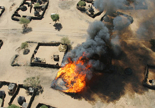
Since Sudanese government soldiers and their proxy militia, the Janjaweed, commenced assaults on rebel forces and civilians of similar ethnic descent, in 2003, the crisis in Darfur has been at the forefront of international discussion and the subject of extensive political, humanitarian, and journalistic work. "Museum Mapping Initiative," a unique collaboration between Google and the United States Holocaust Memorial Museum, makes the history and details of the crisis available to a virtual community, allowing Google Earth users to navigate a map of the region amended with data provided by the U.S. State department, including locations of damaged and destroyed villages, internally displaced person (IDP) and refugee camps in Darfur and Chad, respectively, and zones accessible and inaccessible to humanitarian relief workers. Users navigating the terrain can read testimonies of civilians affected by the conflict, recorded by Amnesty researchers, and view photographs depicting aspects of regional life. Taking advantage of Google Earth's architecture, "Museum Mapping Initiative" also allows users to insert their own placemarks on locations in Darfur and Chad towards constructing specific tours, presentations and readings of the crisis. Through this intersection of interactive technology and progressive historiography, the events and stories surrounding this modern-day atrocity can finally be brought to greater light. - Tyler Coburn

